Deadvlei – A Study In Graphic Forms

The clay pan of Deadvlei contains numerous camel thorn trees that have been dead for at least 600 years.

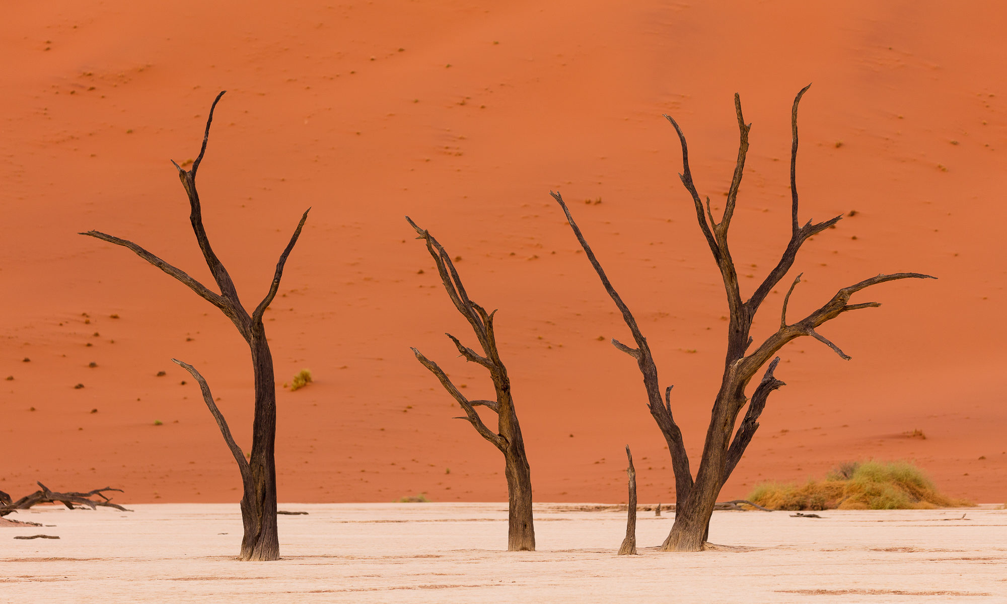
Welcome to Deadvlei, one of those mystical places on earth that simply takes your breath away. There are a few places in the world that have spoken to me this way – whether it’s 5,000 year old Bristlecone Pines clinging to life on a windswept mountain slope, or morning sea fog rolling through a quiet stand of old growth California coastal redwoods (why do these special places always seem to involve trees?). Deadvlei is certainly one of those places.

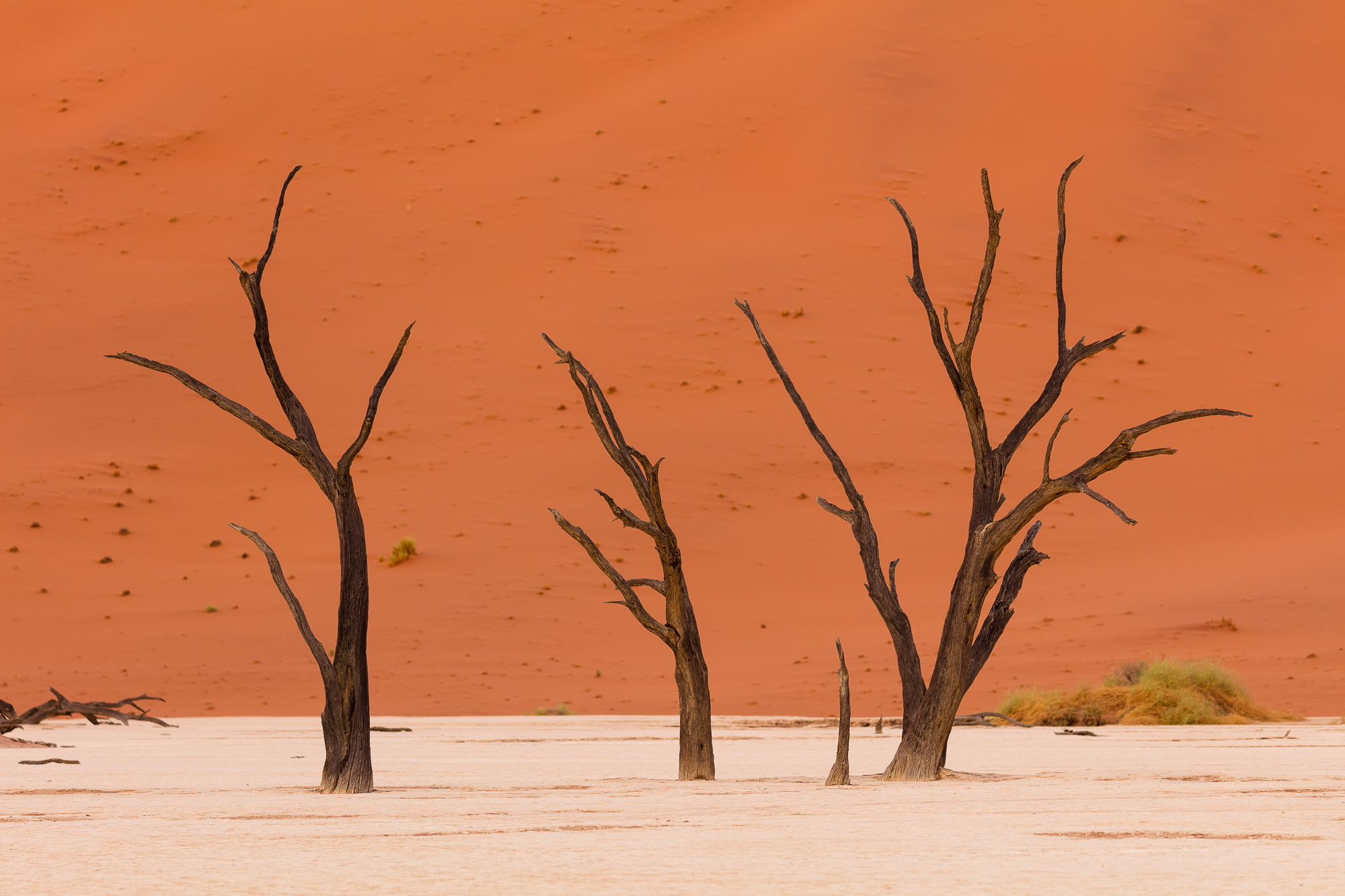
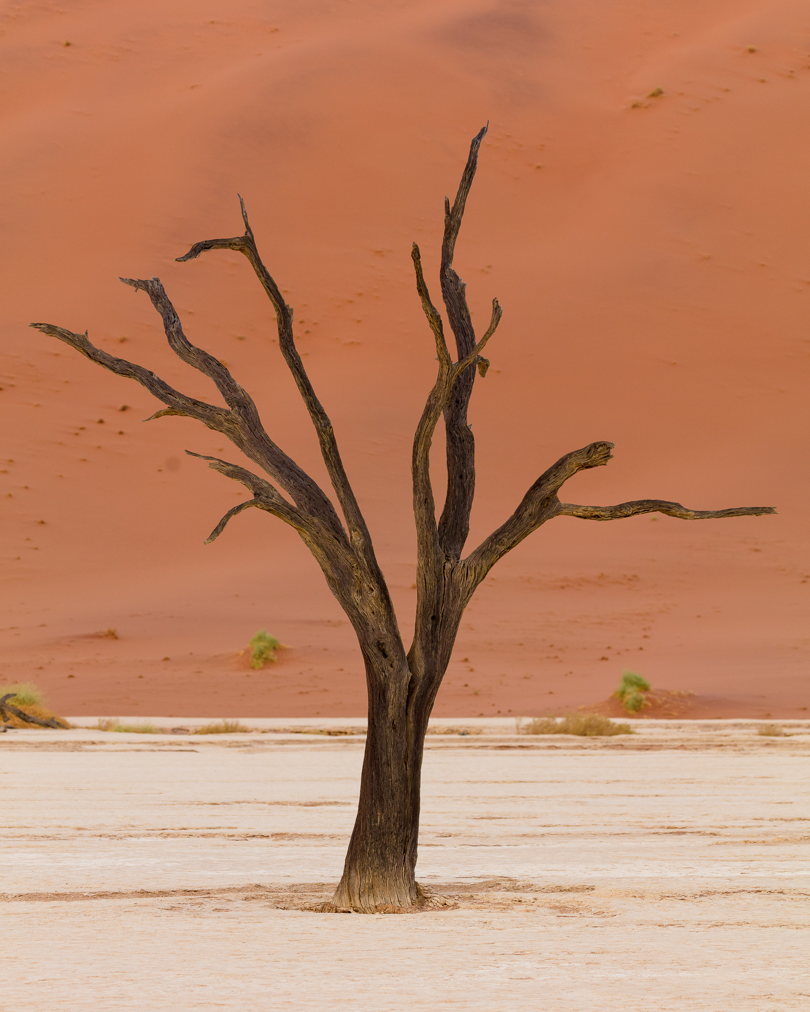
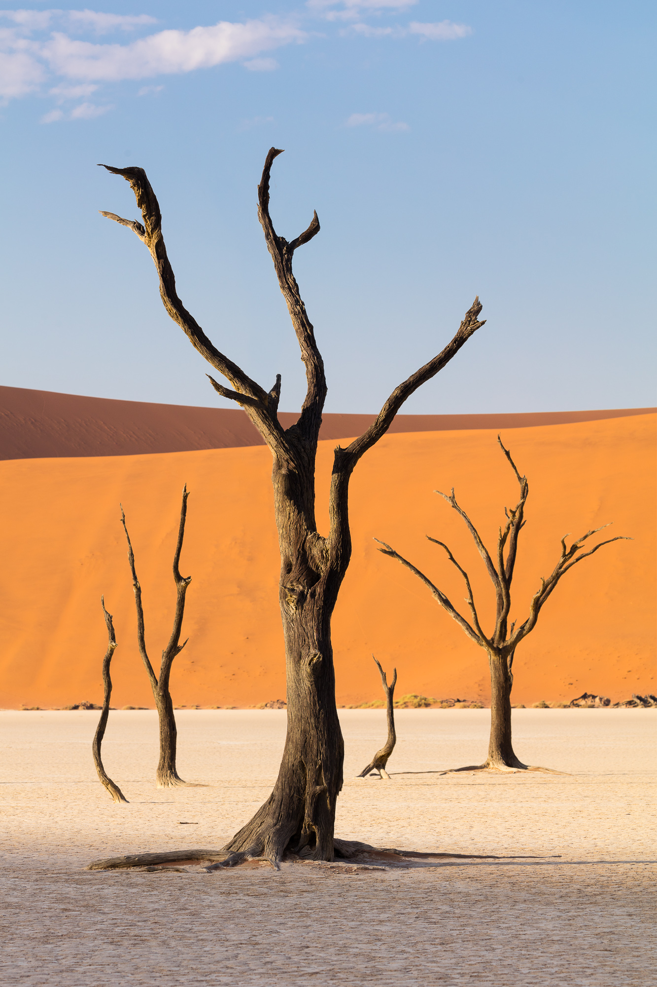
Deadvlei is a dry and dusty river bed, located in the heart of Namib-Naukluft National Park, Namibia. Deadvlei translates to “dead marsh”, taking the Afrikaans word vlei, meaning a seasonal pond or marsh. This area once lined the banks of the Tsauchab river, flooding at times of abundant rainfall. Around 600 to 700 years ago, a great drought hit the region, drying up the river. Blowing sand encroached upon the flood plain, blocking the river’s path and forming the massive dunes that cover the land today. The camel thorn trees that grew in this marsh died, but due to the extremely dry climate, none of the wood decomposed, leaving skeletal husks still standing for hundreds of years. Centuries spent in the hot African sun have scorched the remains into blackened ghosts.

600 years ago, a drought dried up the Tsauchab river, 1000 foot dunes encroached on the dried up marsh, and the river was blocked.

In order to do an on-sight scout and be ready for the light, I arrived before dawn. This involved rising about 4 AM, hopping in a hired safari vehicle (with giant tires) and taking the 45 minute ride among the largest dunes in the world. The asphalt road soon turned to dirt, which turned to sand. Low tire pressure, 4-wheel drive, and high clearance are all musts in this area – no sedans allowed.

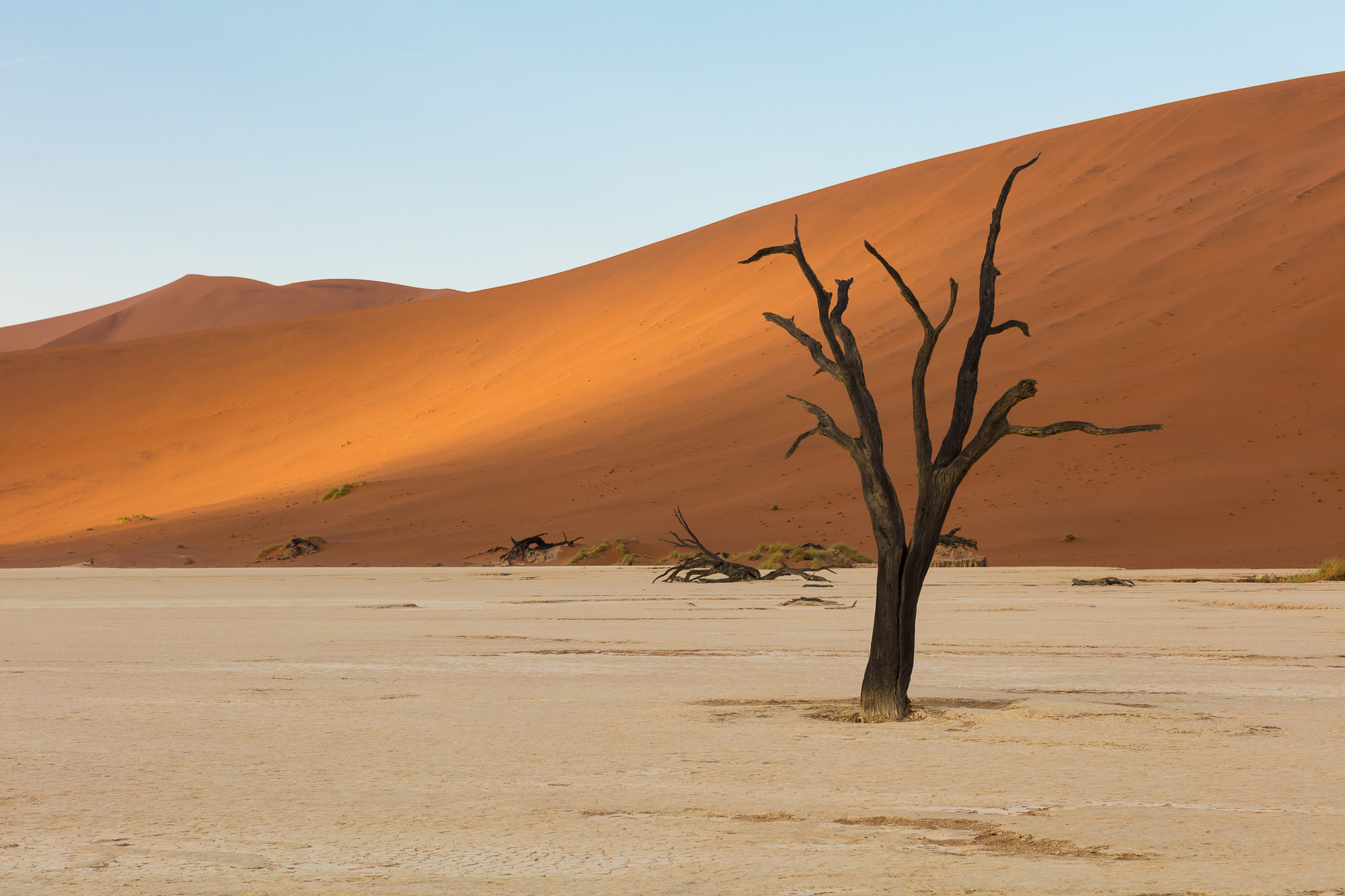
From the drop off, it was a 15 minute hike into the dunes before I topped a rise and saw Deadvlei down below me, surrounded on three sides by immense walls of blood red sand. The tallest point is south east of the clay pan, nicknamed Big Daddy. Standing over 1,000 feet tall, it towers above everything else in the area.

I did a quick scan from my vantage point before descending to a stand of trees. I set up a composition, and waited for the light.

The wood of the dead trees does not decompose because the area is so dry.

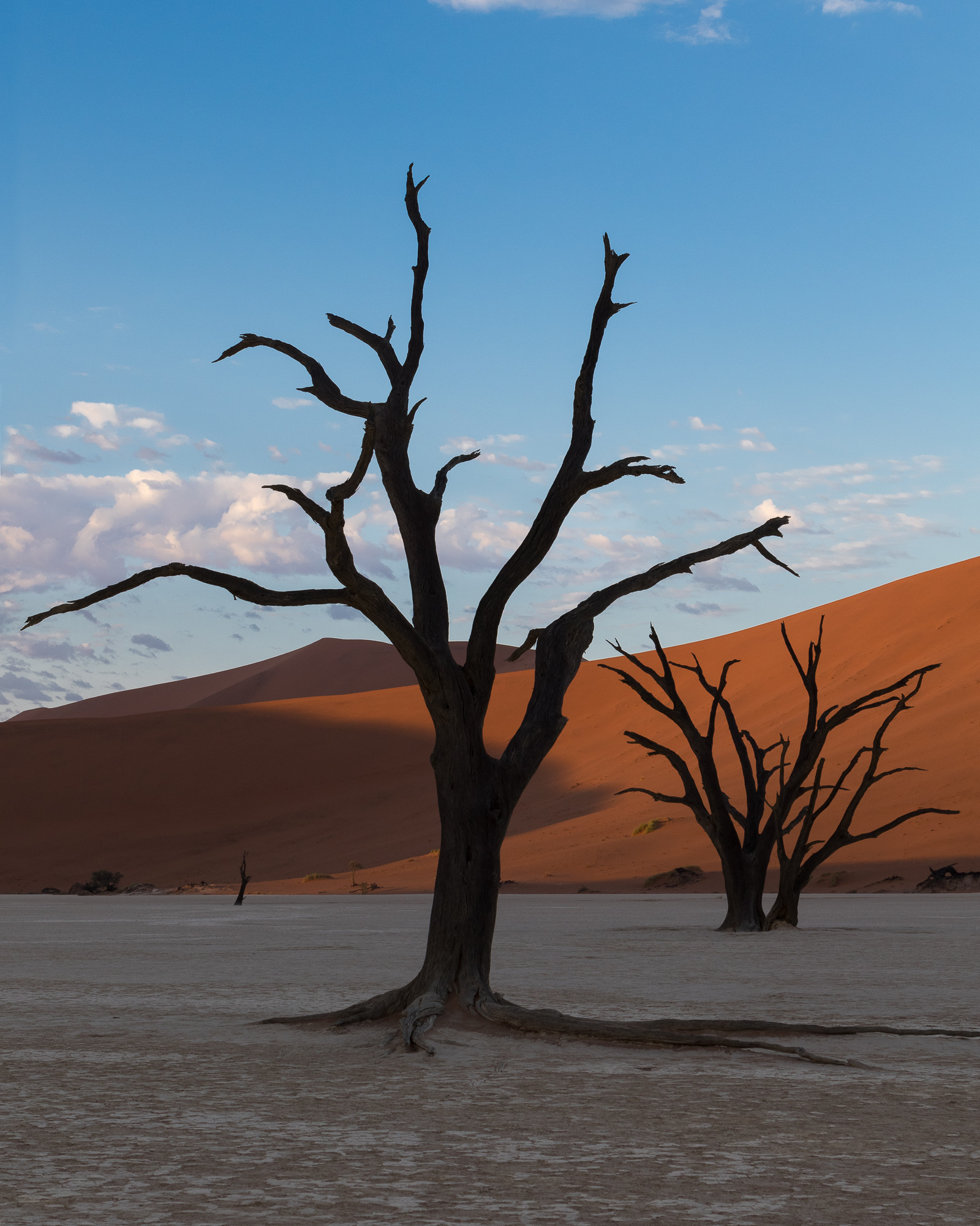
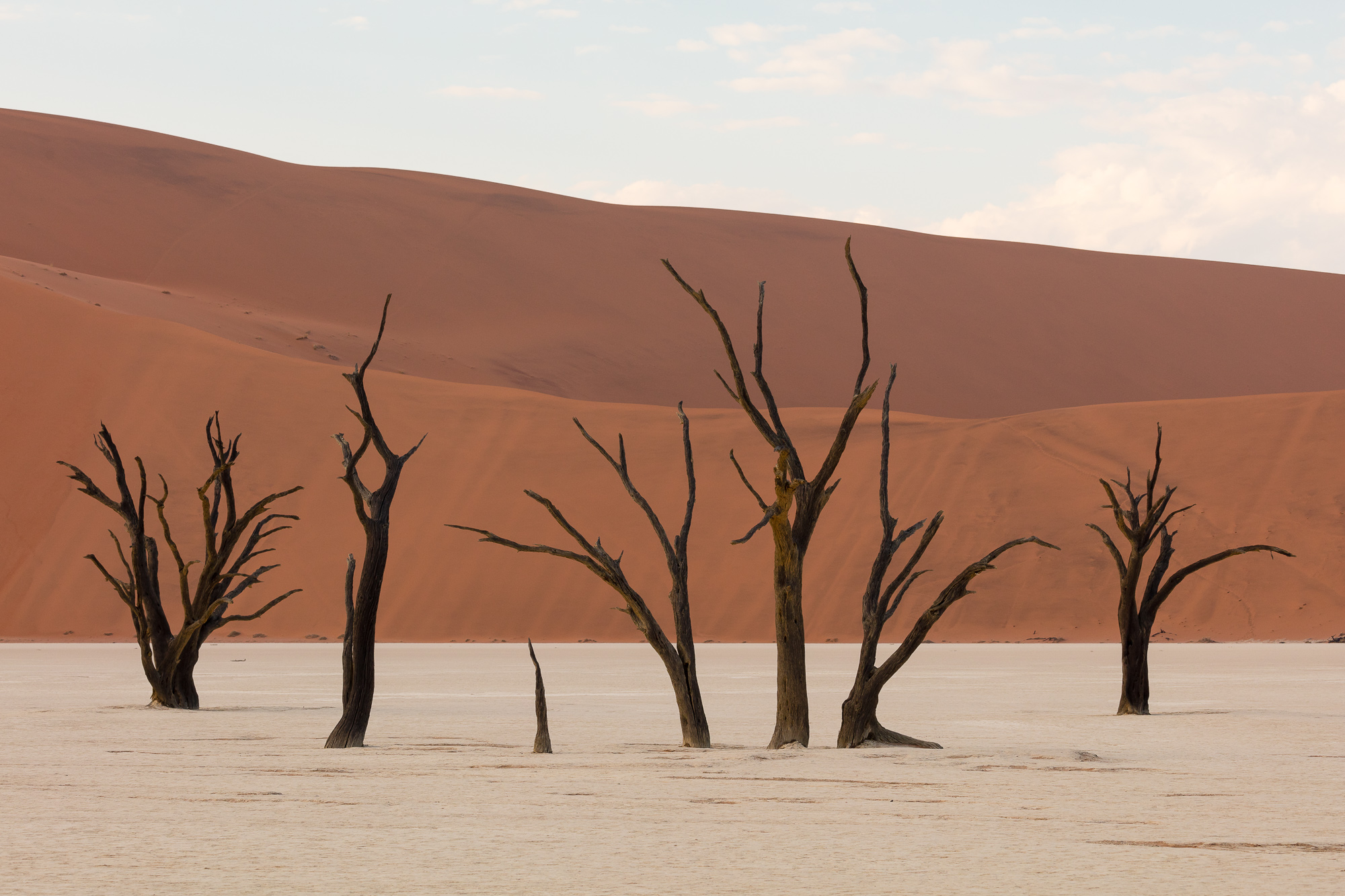
Based on my trip research, I knew much of my shooting at this location would be a study of form and separation. Before I set up for any particular shot, I spent a lot of time looking for the right composition. I needed to avoid unnecessary converging lines, and try to separately my subjects from each other. I would walk around clusters of trees, trying to discern how I would render three dimensions onto a flat, two-dimensional plane.

I imagined the trees in silhouette, reduced to graphical elements of lines and shapes. I moved forward and backward, up and down, trying to find the angles that would convey the subjects in a compositionally elegant manner.

Sun spotlights the side of a dune wall behind a desiccated tree.

The sun moved higher in the sky, spotlighting parts of the landscape through lazy clouds. I looked for new patterns that the light played out across the desert surface.

Tree husks reach out of the clay pan toward the morning sky.

As the desiccated trees moved from shadow to light, their dark forms contrasted against the bright ground and red sand, emphasizing the graphical nature of the scene.

Pulling a three-dimensional stand of trees into a flat plane can be challenging.

This is a place I’ve wanted to visit for a long time. As I was standing in that dusty, dry, ancient river bed, I could hardly believe I was there. I was half a world away from home, and my surroundings could not have been more alien. I truly relish these experiences. Being able to capture an area photographically and share it with others is rewarding, but there is nothing that could replace being there in person.

Gem Lake, Emigrant Wilderness

Last weekend I took a quick two night backpacking trip with some friends, in hopes of hitting the high country of the Sierra Nevada in peak wildflower season. I set my sights on Gem Lake in Emigrant Wilderness – just about the right elevation for flowers this time of year. Having been there before, I knew that even if the place wasn’t in bloom, we’d have a great time and see some amazing scenery.

I like Emigrant Wilderness because there are no trail quotas and it is very easy to get a wilderness permit with short planning. We set out from the Bay Area early Friday morning, stopping at the Mi Wuk Ranger Station on the way up Highway 108. Even though we were taking our time, we still hit the trail by 10AM, plenty of time to reach our 10 mile destination of Gem Lake.

A backpacker hikes along the trail from Crabtree Camp trailhead to Gem Lake, Emigrant Wilderness, CA.

The trail meanders between thick forest and open granite-filled vistas. Most of Emigrant Wilderness is easily accessible cross country due to many gently-sloping wide open granite bowls and domes. This time we stuck to the trail, and made easy progress. Every so often we were rewarded with a scenic vista. If you are not already a lover of granite, after a few hikes in this part of the Sierra you soon will be!

Cliffs to the north of Gem Lake reflect in the still water at sunset, Emigrant Wilderness, CA.

The elevation changes were just enough to tire our bodies by the time we reached Gem Lake. This lake certainly lives up to its name. However, it is very popular and can get quite crowded on the weekend. As it was Friday night, we were able to relax lakeside in relative peace. As the sun set, the wind settled and we got some nice reflections on the water.

Cliffs to the north of Gem Lake reflect in the still water at sunset, Emigrant Wilderness, CA.

The next day we went further up trail and explored Jewelry Lake and Deer Lake. Deer Lake is much larger and Gem or Jewelry, and it was hot enough to warrant a midday dip in its cool waters. This is a great area to take your time and not hurry along the trail. One more night, and it was time to head back.

A winding stream flows into Jewelry Lake, Emigrant Wilderness, CA.

Luckily there were plenty of wildflowers along the trail to keep us entertained. We had perfect weather for our 26 mile journey and everyone enjoyed the change in scenery.

A backpacker hikes along the trail from Crabtree Camp trailhead to Gem Lake, Emigrant Wilderness, CA.

With its easy access and lack of quotas, this is the perfect place for an impromptu night or two in the wilderness.

Gear I used to create the photos in this post:
[amazon_link asins=’B00IAYFDIC,B00T3ERT5S,B0076BNK30,B0079RQZBU,B00OD71FKU’ template=’ProductCarousel’ store=’hankchristens-20′ marketplace=’US’ link_id=’617616e6-918b-11e7-b259-8df1aecbb1d9′]

Lassen Cinder Cone

The Lassen Cinder Cone forms a large round hill when approached from the west, Mt Lassen National Park.

A couple of summers ago I met my brother and dad in Mt. Lassen National Park for a backpacking trip. This park sees one fraction of the backpacking that other national parks get. As a result, you get the feeling of having the back country to yourselves. More importantly for me, this trip would revolve around revisiting the Lassen Cinder Cone that sits in the east part of the park. We had been there many years before on a day hike, but backpacking would give me more time to explore it photographically.

A backpacker is dwarfed by the large Lassen Cinder Cone as he heads up the steep trail to the top, Mt. Lassen National Park.

We spent the night at Snag Lake, and in the morning, approached the Cinder Cone from the south. From there, we reached the steeper of the two trails that wind to the top. In the photo above, you can see my brother as a small speck as we neared the cone from the west.

Two backpackers climb the steep southern trail up the Lassen Cinder Cone. Mt Lassen and the Painted Dunes can be seen to the west.

The trail to the top is built using the loose volcanic scoria that makes up the cone itself. It is only a little more solid than walking up a sand dune, and is not for the faint of heart. This is due not only to the phyisical exhaustion that comes from pushing up such a slope, but also the steepness of the trail itself. At times I felt like I was going to tumble backward down the trail as my backpack made me somewhat off balance.

A large cinder cone sits to the east of Mt. Lassen in Northern California. A trail decends a hundred feet into the mouth of the cinder cone to a large steam vent.

Those who reach the top are rewarded with spectacular views of Mt. Lassen to the west, as well as a chance to peer down into the crater of the cone. A trail even descends into the mouth of the crater, where you can stand next to thermal steam escaping from the ground.

The cinder cone was formed long ago by many small eruptions that threw lava into the air, which cooled into the loose, porous volcanic rock. Over time, this piled up into the 700 foot tall cone that we see today. It is thought to have erupted as recently as the 1650s, though the only activity that remains today is the steam rising from the crater.

A backpacker looks at Mt. Lassen from the top of the Lassen Cinder Cone.

Walking to the western edge of the crater, we were rewarded with views directly across from Mt. Lassen, as well as views of the Painted Dunes below.

The Painted Dunes extend to the forest surrounding Mt. Lassen in Northern California. These volcanic dunes were formed by a thousand year old cinder cone.

The painted dunes are pumice fields formed by oxidation of volcanic ash from earlier eruptions of the Cinder Cone. Its beautiful colors formed because the ash fell on lava that was still hot and forming.

Two backpackers decend the steep southern trail of the Lassen Cinder Cone, Mt Lassen National Park.

After a while at the top, and after we tired of braving the fierce wind, we descended the way we had come up. I tried not to think about the consequences of losing my footing, and took it step by step.

A backpacker heads west away from the Lassen Cinder Cone, Mt Lassen National Park.

Soon we were down and continuing our day’s hike to our destination of Summit Lake. The promise of camp chairs and cold beer quickened our step. It was great to spend time up close with this unusual creation of nature.

Bandon Moody Mornings

A moody sky breaks in early morning over Bandon Beach, Oregon

Recently I published a post about my trip to Bandon Oregon and some of the sunset conditions I faced. Here is a counterpart to that article about the mornings I spent on the beach. Due to the weather, most mornings were overcast and very moody. It was a perfect opportunity to capture a quiet beach in somber lighting.

A moody sky breaks in early morning over Bandon Beach, Oregon

Most mornings had a very low tide, offering more compositional opportunities than sunset. For the photo above I spent some time studying the interplay of shapes between the sand, water, rocks, and their reflections. It is important to separate out the graphical elements in your image to prevent strong lines from overlapping. I had to carefully balance the space in between the large rock reflection and the sand bar jutting into the tide pool, with the spacing between the mid-frame rock and the sea stacks out on the horizon.

Low tide uncovers clusters of mussels, Bandon, Oregon

On another part of the beach, I found a large group of exposed mussels and decided to use them as leading lines out to the large sea stacks in the water. Getting down low with a wide angle lens helped emphasize the mussels in the foreground. Here I used focus stacking to ensure sharp focus throughout the frame.

A low tide exposes large stones and carved sand along Bandon Beach, Oregon

The flat light of the morning lent itself well to black and white conversions. What attracted my eye to this area were the deep lines in the sand cut by the receding water. By converting to black and white, I was able to emphasize these lines by increasing the contrast and bringing out the drama of the image. I also liked the randomness of the rocks strewn about the background of the image. Compositionally, it is a nice juxtaposition of the round shapes of the rocks with the jagged straight lines cut through the sand.

The sun rises on a blue, dreary day along Bandon Beach Oregon

Sometimes instead of adding contrast to an image (as in the black and white image seen above), it is better to showcase the low contrast qualities of the scene. Many mornings there was a foggy mist that settled around the rock formations, and here I wanted to show that atmosphere as well as the blue light cast of the morning.

The sun rises on a blue, dreary day along Bandon Beach Oregon

Finally, this image was shot on the same day as the image above, but I increased the contrast to show off the sharpness of the foreground rocks leading to the rock spire.

It was a lot of fun to really think about why I was attracted to each of these images and use the processing stage to convey those thoughts to the viewer. It is also a reminder that taking the photos is only half of the story. A lot of communication comes through in the processing itself.

Copyright 2017 Hank Christensen